
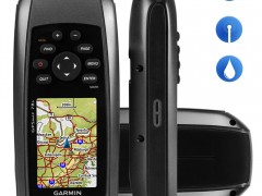

GARMIN GPSMAP 78s
Perfect for water sports or boating, the Garmin GPSMAP 78s is the complete GPS, waterproof, with a 2.6-inch color display screen always leave you on the right track.
The GPSMAP 78s floats which facilitates be found if dropped in the water during her performance, is all rubberized sides, which makes it much more robust and sturdy. Internal memory of 1.7 GB and still has input memory card (SD Card) for you to broaden your maps. Have barometric altimeter and 3-axis compass.
The Garmin GPSMAP 78s has antenna high sensitivity and HotFix ™ satellite prediction determining your position quickly and accurately, thus maintaining accurate information even under dense and deep valleys roofing, you can count on GPSMAP 78 whenever you need. This GPS has preloaded world base map.
• Unit Dimensions: 6.6 x 15.2 x 3.0 cm
• Display Size : 2.6 inch
• Display resolution : 160 x 240 pixels
• Display type : transflective , 65 - K Color TFT
• Battery: 2 AA batteries ( not included ) - recommended NiMH or Lithium
• Battery life: Up to 20 hours
• Waterproof
• Floats in water
• High-sensitivity receiver
• Compatible with USB interface and NMEA 0183
• Basemap
• Electronic Compass
• Barometric altimeter
• Ability to add maps
• Internal Memory: 1.7 GB
• Accepts data cards - microSD ™ ( not included )
• Records up to 2000 Charts , Favourites and Locations
• Records up to 200 routes
• Track log : 10,000
• Record 200 of 200 route points
• Automatic routing - routing on roads bend to bend with optional mapping for detailed roads
• Can be easily used for geocaching
• Compatible with Custom Maps
• Photo navigation - navigate to geotagged photos
• Calendar of hunting and fishing
• Information about the sun and the moon
• Tide Tables
• Area calculation
• POI - ability to add additional points of interest
• Viewer
• Compatible with Garmin Connect ™ - online community where you analyze , categorize and share data
• Supports satellite images (Required signature of Birdseyes package)
• Transfer unit to unit that shares data wirelessly with similar units
Availability to add maps :
Can add maps : water , road and topographic for your GPS is complete and accompany you on any occasion.
Geocaching :
Allows you to download geocaches and details straight to the unit , store and display key information, including location, terrain , difficulty, hints and descriptions . Just upload the GPX file and start using.
Garmin Connect :
Garmin online community that allows you to record , track and share your adventures with other Garmin users.
Kit Comprising of:
• GPSMAP 78
• Cord Wrist
• USB Cable
• Manual